Definition Type: ComplexType
Name: CoordinateSystemAxisType
Namespace: http://www.opengis.net/gml
Type: gml:AbstractCRSObjectType
Containing Schema: coordinateSystems.xsd
Abstract
Documentation:
Definition of a coordinate system axis.
Collapse XSD Schema Diagram:
Drilldown into axisDirection in schema coordinatesystems_xsd Drilldown into axisAbbrev in schema coordinatesystems_xsd Drilldown into axisID in schema coordinatesystems_xsd Drilldown into name in schema gmlbase_xsd Drilldown into description in schema gmlbase_xsd Drilldown into metaDataProperty in schema gmlbase_xsd Drilldown into id in schema gmlbase_xsd Drilldown into AbstractCRSObjectType in schema referencesystems_xsd Drilldown into uom in schema coordinatesystems_xsdXSD Diagram of CoordinateSystemAxisType in schema coordinatesystems_xsd (Geography Markup Language)
Collapse XSD Schema Code:
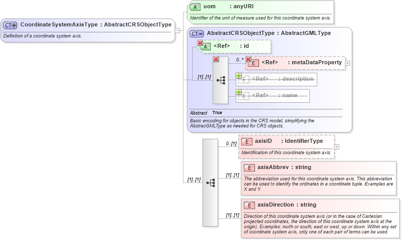
<xsd:complexType name="CoordinateSystemAxisType" xmlns:xsd="http://www.w3.org/2001/XMLSchema">
    <xsd:annotation>
        <xsd:documentation>Definition of a coordinate system axis. </xsd:documentation>
    </xsd:annotation>
    <xsd:complexContent>
        <xsd:extension base="gml:AbstractCRSObjectType">
            <xsd:sequence>
                <xsd:element name="axisID" type="gml:IdentifierType" minOccurs="0">
                    <xsd:annotation>
                        <xsd:documentation>Identification of this coordinate system axis. </xsd:documentation>
                    </xsd:annotation>
                </xsd:element>
                <xsd:element name="axisAbbrev" type="string">
                    <xsd:annotation>
                        <xsd:documentation>The abbreviation used for this coordinate system axis. This abbreviation can be used to identify the ordinates in a coordinate tuple. Examples are X and Y. </xsd:documentation>
                    </xsd:annotation>
                </xsd:element>
                <xsd:element name="axisDirection" type="string">
                    <xsd:annotation>
                        <xsd:documentation>Direction of this coordinate system axis (or in the case of Cartesian projected coordinates, the direction of this coordinate system axis at the origin). Examples: north or south, east or west, up or down. Within any set of coordinate system axis, only one of each pair of terms can be used. </xsd:documentation>
                    </xsd:annotation>
                </xsd:element>
            </xsd:sequence>
            <xsd:attribute name="uom" type="anyURI" use="required">
                <xsd:annotation>
                    <xsd:documentation>Identifier of the unit of measure used for this coordinate system axis. </xsd:documentation>
                </xsd:annotation>
            </xsd:attribute>
        </xsd:extension>
    </xsd:complexContent>
</xsd:complexType>
Collapse Child Elements:
Name Type Min Occurs Max Occurs
metaDataProperty gml:metaDataProperty 0 unbounded
description gml:description 0 (1)
name gml:name 0 unbounded
metaDataProperty gml:metaDataProperty 0 unbounded
axisID gml:axisID 0 (1)
axisAbbrev gml:axisAbbrev (1) (1)
axisDirection gml:axisDirection (1) (1)
Collapse Child Attributes:
Name Type Default Value Use
id gml:id Optional
uom gml:uom Required
Collapse Derivation Tree:
Collapse References:
gml:CoordinateSystemAxis