Definition Type: Element
Name: rangeMeaning
Namespace: http://www.opengis.net/gml/3.2
Type: gml:CodeWithAuthorityType
Containing Schema: coordinateSystems.xsd
Abstract
Documentation:
gml:rangeMeaning describes the meaning of axis value range specified by gml:minimumValue and gml:maximumValue. This element shall be omitted when both gml:minimumValue and gml:maximumValue are omitted. This element should be included when gml:minimumValue and/or gml:maximumValue are included. If this element is omitted when the gml:minimumValue and/or gml:maximumValue are included, the meaning is unspecified. The codeSpace attribute shall reference a source of information specifying the values and meanings of all the allowed string values for this property.
Collapse XSD Schema Diagram:
Drilldown into codeSpace in schema basictypes_xsd Drilldown into CodeWithAuthorityType in schema basictypes_xsdXSD Diagram of rangeMeaning in schema coordinatesystems_xsd (Geography Markup Language)
Collapse XSD Schema Code:
<element name="rangeMeaning" type="gml:CodeWithAuthorityType">
    <annotation>
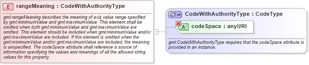
        <documentation>gml:rangeMeaning describes the meaning of axis value range specified by gml:minimumValue and gml:maximumValue. This element shall be omitted when both gml:minimumValue and gml:maximumValue are omitted. This element should be included when gml:minimumValue and/or gml:maximumValue are included. If this element is omitted when the gml:minimumValue and/or gml:maximumValue are included, the meaning is unspecified. The codeSpace attribute shall reference a source of information specifying the values and meanings of all the allowed string values for this property.</documentation>
    </annotation>
</element>
Collapse Child Attributes:
Name Type Default Value Use
codeSpace gml:codeSpace Required
Collapse Derivation Tree: