Definition Type: ComplexType
Name: CoordinateBaseType
Namespace: http://www.openapplications.org/oagis/9
Containing Schema: Components.xsd
Abstract
Documentation:
The OAGIS CoordinateType allows the use of another coordinate system for the use within a warehousing and inventory environment and the geographic coordinat system.
Collapse XSD Schema Diagram:
Drilldown into CoordinateReference in schema components_xsd1 Drilldown into SystemID in schema fields_xsd1 Drilldown into AltitudeMeasure in schema fields_xsd1 Drilldown into Longitude in schema components_xsd1 Drilldown into Latitude in schema components_xsd1XSD Diagram of CoordinateBaseType in schema components_xsd1 (HR-XML - Human Resources XML)
Collapse XSD Schema Code:
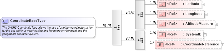
<xsd:complexType name="CoordinateBaseType">
    <xsd:annotation>
        <xsd:documentation source="http://www.openapplications.org/platform/1">The OAGIS CoordinateType allows the use of another coordinate system for the use within a warehousing and inventory environment and the geographic coordinat system.</xsd:documentation>
    </xsd:annotation>
    <xsd:choice>
        <xsd:sequence>
            <xsd:element ref="Latitude" minOccurs="0" />
            <xsd:element ref="Longitude" minOccurs="0" />
            <xsd:element ref="AltitudeMeasure" minOccurs="0" />
        </xsd:sequence>
        <xsd:sequence>
            <xsd:element ref="SystemID" minOccurs="0" />
            <xsd:element ref="CoordinateReference" minOccurs="0" maxOccurs="unbounded" />
        </xsd:sequence>
    </xsd:choice>
</xsd:complexType>
Collapse Child Elements:
Name Type Min Occurs Max Occurs
Latitude oa:Latitude 0 (1)
Longitude oa:Longitude 0 (1)
AltitudeMeasure oa:AltitudeMeasure 0 (1)
SystemID oa:SystemID 0 (1)
CoordinateReference oa:CoordinateReference 0 unbounded
Collapse Derivation Tree:
Collapse References:
oa:CoordinateType