Definition Type: ComplexType
Name: CenterContextType
Namespace: http://niem.gov/niem/external/ogc-openls/1.1.0/dhs-gmo/1.0.0
Containing Schema: ols.xsd
Abstract
Collapse XSD Schema Diagram:
Drilldown into Radius in schema ols_xsd Drilldown into DPI in schema ols_xsd Drilldown into DisplayScale in schema ols_xsd Drilldown into CenterPoint in schema ols_xsd Drilldown into SRS in schema ols_xsd Drilldown into azimuth in schema ols_xsdXSD Diagram of CenterContextType in schema ols_xsd (National Information Exchange Model (NEIM))
Collapse XSD Schema Code:
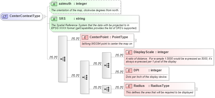
<complexType name="CenterContextType">
    <annotation>
        <appinfo source="ADT.xsd" />
    </annotation>
    <sequence>
        <element name="CenterPoint" type="gml:PointType">
            <annotation>
                <documentation>lat/long WGS84 point to center the map on</documentation>
            </annotation>
            <!-- type="xls:PointType"> -->
        </element>
        <choice>
            <sequence>
                <element name="DisplayScale" type="integer">
                    <annotation>
                        <documentation>A ratio of distance.  For example 1:5000 would be expressed as 5000, it's always expressed per 1 pixel of the display</documentation>
                    </annotation>
                </element>
                <element name="DPI" type="integer">
                    <annotation>
                        <documentation>Dots per Inch of the display device.</documentation>
                    </annotation>
                </element>
            </sequence>
            <sequence>
                <element name="Radius" type="xls:RadiusType">
                    <annotation>
                        <documentation>This defines the area that will be required to be displayed</documentation>
                    </annotation>
                </element>
            </sequence>
        </choice>
    </sequence>
    <attribute name="azimuth" type="integer" use="optional">
        <annotation>
            <documentation>The orientation of the map, clockwise degrees from north.</documentation>
        </annotation>
    </attribute>
    <attribute name="SRS" type="string" use="required">
        <annotation>
            <documentation>The Spatial Reference System that the data with be projected to in EPSG:XXXX format (getCapabilites provides the list of SRS's supported).</documentation>
        </annotation>
    </attribute>
</complexType>
Collapse Child Elements:
Name Type Min Occurs Max Occurs
CenterPoint xls:CenterPoint (1) (1)
DisplayScale xls:DisplayScale (1) (1)
DPI xls:DPI (1) (1)
Radius xls:Radius (1) (1)
Collapse Child Attributes:
Name Type Default Value Use
azimuth xls:azimuth Optional
SRS xls:SRS Required
Collapse Derivation Tree:
Collapse References:
xls:CenterContext