Definition Type: Element
Name: CoordinateSystem
Namespace: http://www.landxml.org/schema/LandXML-1.1
Containing Schema: LandXML-1.1.xsd
Abstract
Documentation:
Simplified coordinate systems definitions to reuse work done by EPSG (European Petroleum Survey Group) EPSG Code: EPSG has reserved the integer range 0 to 32767 for use as codes for coordinate systems. Example: Represents Australian Map Grid Zone 52 name="AGD66 - AMG Zone 52" , epsgCode="20252" Example: Represents Colorado CS27 South Zone name="NAD27-Colorado South" , epsgCode="26755"
Collapse XSD Schema Diagram:
Drilldown into Feature in schema landxml-1_1_xsd Drilldown into Start in schema landxml-1_1_xsd Drilldown into verticalCoordinateSystemName in schema landxml-1_1_xsd Drilldown into geocentricCoordinateSystemName in schema landxml-1_1_xsd Drilldown into projectedCoordinateSystemName in schema landxml-1_1_xsd Drilldown into geographicCoordinateSystemName in schema landxml-1_1_xsd Drilldown into localCoordinateSystemName in schema landxml-1_1_xsd Drilldown into compoundCoordinateSystemName in schema landxml-1_1_xsd Drilldown into horizontalCoordinateSystemName in schema landxml-1_1_xsd Drilldown into fittedCoordinateSystemName in schema landxml-1_1_xsd Drilldown into ellipsoidName in schema landxml-1_1_xsd Drilldown into verticalDatum in schema landxml-1_1_xsd Drilldown into horizontalDatum in schema landxml-1_1_xsd Drilldown into datum in schema landxml-1_1_xsd Drilldown into rotationAngle in schema landxml-1_1_xsd Drilldown into epsgCode in schema landxml-1_1_xsd Drilldown into fileLocation in schema landxml-1_1_xsd Drilldown into name in schema landxml-1_1_xsd Drilldown into desc in schema landxml-1_1_xsdXSD Diagram of CoordinateSystem in schema landxml-1_1_xsd (National Information Exchange Model (NEIM))
Collapse XSD Schema Code:
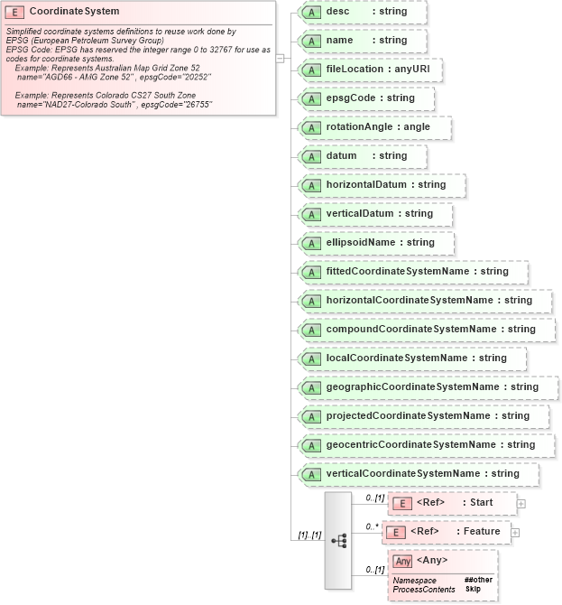
<xs:element name="CoordinateSystem">
    <xs:annotation>
        <xs:documentation>
			     Simplified coordinate systems definitions to reuse work done by
				EPSG (European Petroleum Survey Group)
				EPSG Code: EPSG has reserved the integer range 0 to 32767 for use as codes for coordinate systems.
                    Example: Represents Australian Map Grid Zone 52
                     name="AGD66 - AMG Zone 52" , epsgCode="20252" 

                    Example: Represents Colorado CS27 South Zone
                     name="NAD27-Colorado South" , epsgCode="26755" 
				</xs:documentation>
    </xs:annotation>
    <xs:complexType>
        <xs:sequence>
            <xs:element ref="Start" minOccurs="0" />
            <xs:element ref="Feature" minOccurs="0" maxOccurs="unbounded" />
            <xs:any namespace="##other" processContents="skip" minOccurs="0" />
        </xs:sequence>
        <xs:attribute name="desc" type="xs:string" />
        <xs:attribute name="name" type="xs:string" />
        <xs:attribute name="fileLocation" type="xs:anyURI" />
        <xs:attribute name="epsgCode" type="xs:string" />
        <xs:attribute name="rotationAngle" type="angle" />
        <xs:attribute name="datum" type="xs:string" />
        <xs:attribute name="horizontalDatum" type="xs:string" />
        <xs:attribute name="verticalDatum" type="xs:string" />
        <xs:attribute name="ellipsoidName" type="xs:string" />
        <xs:attribute name="fittedCoordinateSystemName" type="xs:string" />
        <xs:attribute name="horizontalCoordinateSystemName" type="xs:string" />
        <xs:attribute name="compoundCoordinateSystemName" type="xs:string" />
        <xs:attribute name="localCoordinateSystemName" type="xs:string" />
        <xs:attribute name="geographicCoordinateSystemName" type="xs:string" />
        <xs:attribute name="projectedCoordinateSystemName" type="xs:string" />
        <xs:attribute name="geocentricCoordinateSystemName" type="xs:string" />
        <xs:attribute name="verticalCoordinateSystemName" type="xs:string" />
        <!-- should obit these, never used -->
        <!-- *********************** -->
    </xs:complexType>
</xs:element>
Collapse Child Elements:
Name Type Min Occurs Max Occurs
Start land:Start 0 (1)
Feature land:Feature 0 unbounded
<xs:any> Allowed namespace: '##other' 0 (1)
Collapse Child Attributes:
Name Type Default Value Use
desc land:desc (Optional)
name land:name (Optional)
fileLocation land:fileLocation (Optional)
epsgCode land:epsgCode (Optional)
rotationAngle land:rotationAngle (Optional)
datum land:datum (Optional)
horizontalDatum land:horizontalDatum (Optional)
verticalDatum land:verticalDatum (Optional)
ellipsoidName land:ellipsoidName (Optional)
fittedCoordinateSystemName land:fittedCoordinateSystemName (Optional)
horizontalCoordinateSystemName land:horizontalCoordinateSystemName (Optional)
compoundCoordinateSystemName land:compoundCoordinateSystemName (Optional)
localCoordinateSystemName land:localCoordinateSystemName (Optional)
geographicCoordinateSystemName land:geographicCoordinateSystemName (Optional)
projectedCoordinateSystemName land:projectedCoordinateSystemName (Optional)
geocentricCoordinateSystemName land:geocentricCoordinateSystemName (Optional)
verticalCoordinateSystemName land:verticalCoordinateSystemName (Optional)