Definition Type: Element
Name: RawObservation
Namespace: http://www.landxml.org/schema/LandXML-1.1
Containing Schema: LandXML-1.1.xsd
Abstract
Collapse XSD Schema Diagram:
Drilldown into Feature in schema landxml-1_1_xsd Drilldown into FieldNote in schema landxml-1_1_xsd Drilldown into OffsetVals in schema landxml-1_1_xsd Drilldown into TargetPoint in schema landxml-1_1_xsd Drilldown into timeStamp in schema landxml-1_1_xsd Drilldown into coordGeomRefs in schema landxml-1_1_xsd Drilldown into directFace in schema landxml-1_1_xsd Drilldown into unused in schema landxml-1_1_xsd Drilldown into azimuth in schema landxml-1_1_xsd Drilldown into vertDistance in schema landxml-1_1_xsd Drilldown into horizDistance in schema landxml-1_1_xsd Drilldown into zenithAngle in schema landxml-1_1_xsd Drilldown into slopeDistance in schema landxml-1_1_xsd Drilldown into horizAngle in schema landxml-1_1_xsd Drilldown into targetHeight in schema landxml-1_1_xsd Drilldown into purpose in schema landxml-1_1_xsd Drilldown into setID in schema landxml-1_1_xsd Drilldown into targetSetupID in schema landxml-1_1_xsd Drilldown into setupID in schema landxml-1_1_xsdXSD Diagram of RawObservation in schema landxml-1_1_xsd (National Information Exchange Model (NEIM))
Collapse XSD Schema Code:
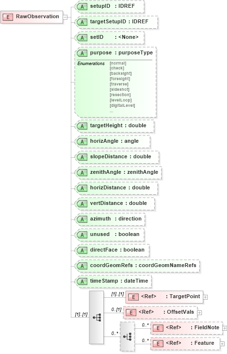
<xs:element name="RawObservation">
    <xs:annotation>
        <xs:documentation />
    </xs:annotation>
    <xs:complexType>
        <xs:sequence>
            <xs:element ref="TargetPoint" />
            <xs:element ref="OffsetVals" minOccurs="0" />
            <xs:choice minOccurs="0" maxOccurs="unbounded">
                <xs:element ref="FieldNote" minOccurs="0" maxOccurs="unbounded" />
                <xs:element ref="Feature" minOccurs="0" maxOccurs="unbounded" />
            </xs:choice>
        </xs:sequence>
        <xs:attribute name="setupID" type="xs:IDREF" />
        <xs:attribute name="targetSetupID" type="xs:IDREF" />
        <xs:attribute name="setID" />
        <xs:attribute name="purpose" type="purposeType" />
        <xs:attribute name="targetHeight" type="xs:double" />
        <xs:attribute name="horizAngle" type="angle" use="optional" />
        <xs:attribute name="slopeDistance" type="xs:double" use="optional" />
        <xs:attribute name="zenithAngle" type="zenithAngle" use="optional" />
        <xs:attribute name="horizDistance" type="xs:double" />
        <xs:attribute name="vertDistance" type="xs:double" />
        <xs:attribute name="azimuth" type="direction" use="optional" />
        <xs:attribute name="unused" type="xs:boolean" />
        <xs:attribute name="directFace" type="xs:boolean" />
        <xs:attribute name="coordGeomRefs" type="coordGeomNameRefs" />
        <xs:attribute name="timeStamp" type="xs:dateTime" />
        <!-- ‘unused’ = boolean attribute to indicate the record is not used. 
			'directFace' = indicates the scope is flipped – true if the scope is not flipped, false if it is. -->
        <!-- coordGeomRefs identifies one or more 'name' values that link to specific <Line>, <Curve>, <Spiral> or <IrregularLine> in a <CoordGeom> element. This allows linking an survey observation to specific <Parcel>.<CoordGeom> based geometry. -->
    </xs:complexType>
</xs:element>
Collapse Child Elements:
Name Type Min Occurs Max Occurs
TargetPoint land:TargetPoint (1) (1)
OffsetVals land:OffsetVals 0 (1)
FieldNote land:FieldNote 0 unbounded
Feature land:Feature 0 unbounded
Collapse Child Attributes:
Name Type Default Value Use
setupID land:setupID (Optional)
targetSetupID land:targetSetupID (Optional)
setID land:setID (Optional)
purpose land:purpose (Optional)
targetHeight land:targetHeight (Optional)
horizAngle land:horizAngle Optional
slopeDistance land:slopeDistance Optional
zenithAngle land:zenithAngle Optional
horizDistance land:horizDistance (Optional)
vertDistance land:vertDistance (Optional)
azimuth land:azimuth Optional
unused land:unused (Optional)
directFace land:directFace (Optional)
coordGeomRefs land:coordGeomRefs (Optional)
timeStamp land:timeStamp (Optional)