Definition Type: Element
Name: ReducedArcObservation
Namespace: http://www.landxml.org/schema/LandXML-1.1
Containing Schema: LandXML-1.1.xsd
Abstract
Documentation:
As we discussed this element is used to provide measured information for calculating boundary arcs. The definition information required is quite different to the curve element
Collapse XSD Schema Diagram:
Drilldown into Feature in schema landxml-1_1_xsd Drilldown into FieldNote in schema landxml-1_1_xsd Drilldown into OffsetVals in schema landxml-1_1_xsd Drilldown into TargetPoint in schema landxml-1_1_xsd Drilldown into oID in schema landxml-1_1_xsd Drilldown into state in schema landxml-1_1_xsd Drilldown into desc in schema landxml-1_1_xsd Drilldown into name in schema landxml-1_1_xsd Drilldown into coordGeomRefs in schema landxml-1_1_xsd Drilldown into lengthAdoptionFactor in schema landxml-1_1_xsd Drilldown into azimuthAdoptionFactor in schema landxml-1_1_xsd Drilldown into azimuthAccClass in schema landxml-1_1_xsd Drilldown into lengthAccClass in schema landxml-1_1_xsd Drilldown into adoptedSurvey in schema landxml-1_1_xsd Drilldown into arcType in schema landxml-1_1_xsd Drilldown into date in schema landxml-1_1_xsd Drilldown into arcLengthAccuracy in schema landxml-1_1_xsd Drilldown into arcAzimuthAccuracy in schema landxml-1_1_xsd Drilldown into equipmentUsed in schema landxml-1_1_xsd Drilldown into rot in schema landxml-1_1_xsd Drilldown into length in schema landxml-1_1_xsd Drilldown into radius in schema landxml-1_1_xsd Drilldown into chordAzimuth in schema landxml-1_1_xsd Drilldown into setID in schema landxml-1_1_xsd Drilldown into targetSetupID in schema landxml-1_1_xsd Drilldown into setupID in schema landxml-1_1_xsd Drilldown into purpose in schema landxml-1_1_xsdXSD Diagram of ReducedArcObservation in schema landxml-1_1_xsd (National Information Exchange Model (NEIM))
Collapse XSD Schema Code:
<xs:element name="ReducedArcObservation">
    <xs:annotation>
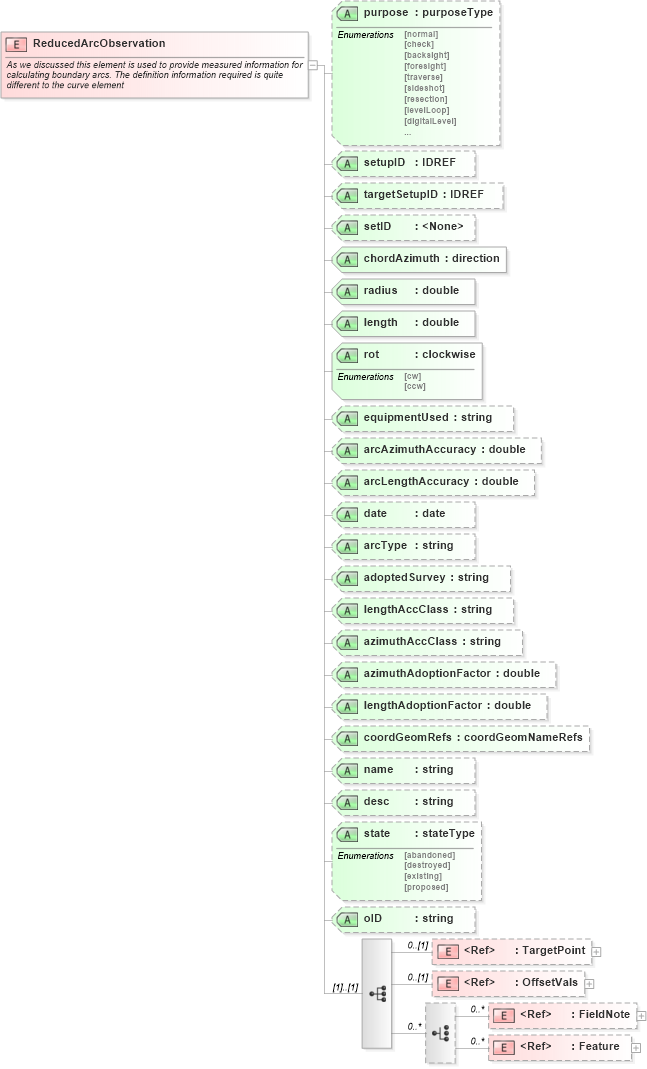
        <xs:documentation>As we discussed this element is used to provide measured information for calculating boundary arcs. The definition information required is quite different to the curve element</xs:documentation>
    </xs:annotation>
    <xs:complexType>
        <xs:sequence>
            <xs:element ref="TargetPoint" minOccurs="0" />
            <xs:element ref="OffsetVals" minOccurs="0" />
            <xs:choice minOccurs="0" maxOccurs="unbounded">
                <xs:element ref="FieldNote" minOccurs="0" maxOccurs="unbounded" />
                <xs:element ref="Feature" minOccurs="0" maxOccurs="unbounded" />
            </xs:choice>
        </xs:sequence>
        <xs:attribute name="purpose" type="purposeType" />
        <xs:attribute name="setupID" type="xs:IDREF" />
        <xs:attribute name="targetSetupID" type="xs:IDREF" />
        <xs:attribute name="setID" />
        <xs:attribute name="chordAzimuth" type="direction" use="required" />
        <xs:attribute name="radius" type="xs:double" use="required" />
        <xs:attribute name="length" type="xs:double" use="required" />
        <xs:attribute name="rot" type="clockwise" use="required" />
        <xs:attribute name="equipmentUsed" type="xs:string" />
        <xs:attribute name="arcAzimuthAccuracy" type="xs:double" />
        <xs:attribute name="arcLengthAccuracy" type="xs:double" />
        <xs:attribute name="date" type="xs:date" />
        <xs:attribute name="arcType" type="xs:string" />
        <xs:attribute name="adoptedSurvey" type="xs:string" />
        <xs:attribute name="lengthAccClass" type="xs:string" />
        <xs:attribute name="azimuthAccClass" type="xs:string" />
        <xs:attribute name="azimuthAdoptionFactor" type="xs:double" />
        <xs:attribute name="lengthAdoptionFactor" type="xs:double" />
        <xs:attribute name="coordGeomRefs" type="coordGeomNameRefs" />
        <xs:attribute name="name" type="xs:string" />
        <xs:attribute name="desc" type="xs:string" />
        <xs:attribute name="state" type="stateType" />
        <xs:attribute name="oID" type="xs:string" />
        <!-- coordGeomRefs identifies one or more 'name' values that link to specific <Line>, <Curve>, <Spiral> or <IrregularLine> in a <CoordGeom> element. This allows linking an survey observation to specific <Parcel>.<CoordGeom> based geometry. -->
    </xs:complexType>
</xs:element>
Collapse Child Elements:
Name Type Min Occurs Max Occurs
TargetPoint land:TargetPoint 0 (1)
OffsetVals land:OffsetVals 0 (1)
FieldNote land:FieldNote 0 unbounded
Feature land:Feature 0 unbounded
Collapse Child Attributes:
Name Type Default Value Use
purpose land:purpose (Optional)
setupID land:setupID (Optional)
targetSetupID land:targetSetupID (Optional)
setID land:setID (Optional)
chordAzimuth land:chordAzimuth Required
radius land:radius Required
length land:length Required
rot land:rot Required
equipmentUsed land:equipmentUsed (Optional)
arcAzimuthAccuracy land:arcAzimuthAccuracy (Optional)
arcLengthAccuracy land:arcLengthAccuracy (Optional)
date land:date (Optional)
arcType land:arcType (Optional)
adoptedSurvey land:adoptedSurvey (Optional)
lengthAccClass land:lengthAccClass (Optional)
azimuthAccClass land:azimuthAccClass (Optional)
azimuthAdoptionFactor land:azimuthAdoptionFactor (Optional)
lengthAdoptionFactor land:lengthAdoptionFactor (Optional)
coordGeomRefs land:coordGeomRefs (Optional)
name land:name (Optional)
desc land:desc (Optional)
state land:state (Optional)
oID land:oID (Optional)