Definition Type: Element
Name: ReducedObservation
Namespace: http://www.landxml.org/schema/LandXML-1.1
Containing Schema: LandXML-1.1.xsd
Abstract
Documentation:
This has been modified to include new fields such as accuracy, date, class and adoption. I've added in bearing (azimuth is in terms of true north whereas bearing is the projection north) - maybe this doesn't matter, may need to discuss
Collapse XSD Schema Diagram:
Drilldown into Feature in schema landxml-1_1_xsd Drilldown into FieldNote in schema landxml-1_1_xsd Drilldown into OffsetVals in schema landxml-1_1_xsd Drilldown into TargetPoint in schema landxml-1_1_xsd Drilldown into spherDistance in schema landxml-1_1_xsd Drilldown into MSLDistance in schema landxml-1_1_xsd Drilldown into oID in schema landxml-1_1_xsd Drilldown into state in schema landxml-1_1_xsd Drilldown into desc in schema landxml-1_1_xsd Drilldown into name in schema landxml-1_1_xsd Drilldown into coordGeomRefs in schema landxml-1_1_xsd Drilldown into distanceAdoptionFactor in schema landxml-1_1_xsd Drilldown into azimuthAdoptionFactor in schema landxml-1_1_xsd Drilldown into azimuthAccClass in schema landxml-1_1_xsd Drilldown into distanceAccClass in schema landxml-1_1_xsd Drilldown into adoptedDistanceSurvey in schema landxml-1_1_xsd Drilldown into adoptedAzimuthSurvey in schema landxml-1_1_xsd Drilldown into azimuthType in schema landxml-1_1_xsd Drilldown into distanceType in schema landxml-1_1_xsd Drilldown into date in schema landxml-1_1_xsd Drilldown into distanceAccuracy in schema landxml-1_1_xsd Drilldown into azimuthAccuracy in schema landxml-1_1_xsd Drilldown into equipmentUsed in schema landxml-1_1_xsd Drilldown into zenithAngle in schema landxml-1_1_xsd Drilldown into slopeDistance in schema landxml-1_1_xsd Drilldown into horizAngle in schema landxml-1_1_xsd Drilldown into vertDistance in schema landxml-1_1_xsd Drilldown into horizDistance in schema landxml-1_1_xsd Drilldown into azimuth in schema landxml-1_1_xsd Drilldown into targetHeight in schema landxml-1_1_xsd Drilldown into setID in schema landxml-1_1_xsd Drilldown into targetSetupID in schema landxml-1_1_xsd Drilldown into setupID in schema landxml-1_1_xsd Drilldown into purpose in schema landxml-1_1_xsdXSD Diagram of ReducedObservation in schema landxml-1_1_xsd (National Information Exchange Model (NEIM))
Collapse XSD Schema Code:
<xs:element name="ReducedObservation">
    <xs:annotation>
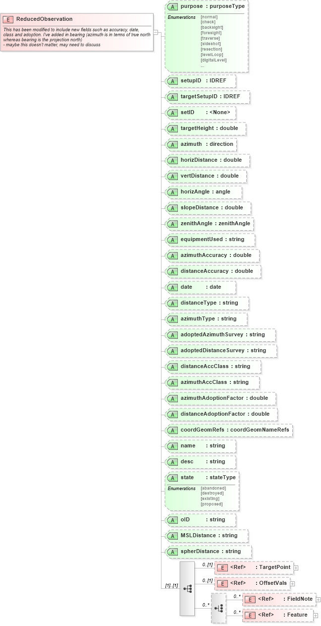
        <xs:documentation>This has been modified to include new fields such as accuracy, date, class and adoption. I've added in bearing (azimuth is in terms of true north whereas bearing is the projection north) </xs:documentation>
        <xs:documentation> - maybe this doesn't matter, may need to discuss</xs:documentation>
    </xs:annotation>
    <xs:complexType>
        <xs:sequence>
            <xs:element ref="TargetPoint" minOccurs="0" />
            <xs:element ref="OffsetVals" minOccurs="0" />
            <xs:choice minOccurs="0" maxOccurs="unbounded">
                <xs:element ref="FieldNote" minOccurs="0" maxOccurs="unbounded" />
                <xs:element ref="Feature" minOccurs="0" maxOccurs="unbounded" />
            </xs:choice>
        </xs:sequence>
        <xs:attribute name="purpose" type="purposeType" />
        <xs:attribute name="setupID" type="xs:IDREF" />
        <xs:attribute name="targetSetupID" type="xs:IDREF" />
        <xs:attribute name="setID" />
        <xs:attribute name="targetHeight" type="xs:double" />
        <xs:attribute name="azimuth" type="direction" use="optional" />
        <xs:attribute name="horizDistance" type="xs:double" use="optional" />
        <xs:attribute name="vertDistance" type="xs:double" use="optional" />
        <xs:attribute name="horizAngle" type="angle" use="optional" />
        <xs:attribute name="slopeDistance" type="xs:double" use="optional" />
        <xs:attribute name="zenithAngle" type="zenithAngle" use="optional" />
        <xs:attribute name="equipmentUsed" type="xs:string" />
        <xs:attribute name="azimuthAccuracy" type="xs:double" />
        <xs:attribute name="distanceAccuracy" type="xs:double" />
        <xs:attribute name="date" type="xs:date" />
        <xs:attribute name="distanceType" type="xs:string" />
        <xs:attribute name="azimuthType" type="xs:string" />
        <xs:attribute name="adoptedAzimuthSurvey" type="xs:string" />
        <xs:attribute name="adoptedDistanceSurvey" type="xs:string" />
        <xs:attribute name="distanceAccClass" type="xs:string" />
        <xs:attribute name="azimuthAccClass" type="xs:string" />
        <xs:attribute name="azimuthAdoptionFactor" type="xs:double" />
        <xs:attribute name="distanceAdoptionFactor" type="xs:double" />
        <xs:attribute name="coordGeomRefs" type="coordGeomNameRefs" />
        <xs:attribute name="name" type="xs:string" />
        <xs:attribute name="desc" type="xs:string" />
        <xs:attribute name="state" type="stateType" />
        <xs:attribute name="oID" type="xs:string" />
        <xs:attribute name="MSLDistance" type="xs:string" />
        <xs:attribute name="spherDistance" type="xs:string" />
        <!-- coordGeomRefs identifies one or more 'name' values that link to specific <Line>, <Curve>, <Spiral> or <IrregularLine> in a <CoordGeom> element. This allows linking an survey observation to specific <Parcel>.<CoordGeom> based geometry. -->
    </xs:complexType>
</xs:element>
Collapse Child Elements:
Name Type Min Occurs Max Occurs
TargetPoint land:TargetPoint 0 (1)
OffsetVals land:OffsetVals 0 (1)
FieldNote land:FieldNote 0 unbounded
Feature land:Feature 0 unbounded
Collapse Child Attributes:
Name Type Default Value Use
purpose land:purpose (Optional)
setupID land:setupID (Optional)
targetSetupID land:targetSetupID (Optional)
setID land:setID (Optional)
targetHeight land:targetHeight (Optional)
azimuth land:azimuth Optional
horizDistance land:horizDistance Optional
vertDistance land:vertDistance Optional
horizAngle land:horizAngle Optional
slopeDistance land:slopeDistance Optional
zenithAngle land:zenithAngle Optional
equipmentUsed land:equipmentUsed (Optional)
azimuthAccuracy land:azimuthAccuracy (Optional)
distanceAccuracy land:distanceAccuracy (Optional)
date land:date (Optional)
distanceType land:distanceType (Optional)
azimuthType land:azimuthType (Optional)
adoptedAzimuthSurvey land:adoptedAzimuthSurvey (Optional)
adoptedDistanceSurvey land:adoptedDistanceSurvey (Optional)
distanceAccClass land:distanceAccClass (Optional)
azimuthAccClass land:azimuthAccClass (Optional)
azimuthAdoptionFactor land:azimuthAdoptionFactor (Optional)
distanceAdoptionFactor land:distanceAdoptionFactor (Optional)
coordGeomRefs land:coordGeomRefs (Optional)
name land:name (Optional)
desc land:desc (Optional)
state land:state (Optional)
oID land:oID (Optional)
MSLDistance land:MSLDistance (Optional)
spherDistance land:spherDistance (Optional)