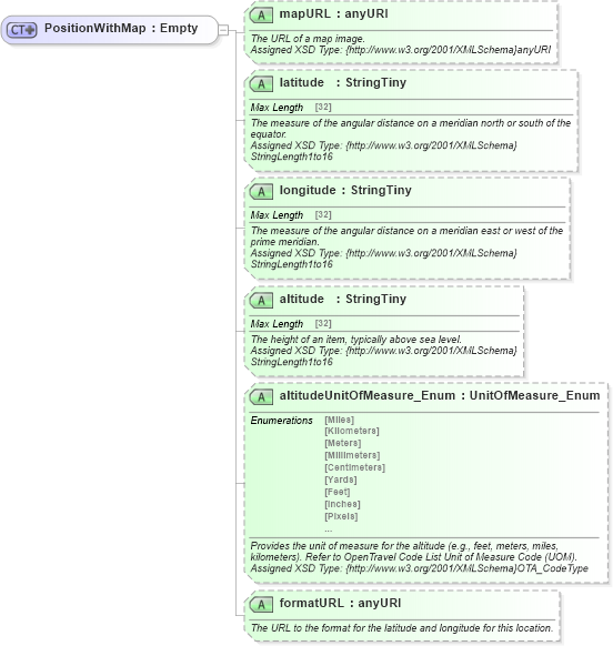
<xsd:complexType name="PositionWithMap">
    <xsd:annotation>
        <xsd:appinfo>
            <otm:OTA2Entity type="ValueWithAttributes" xmlns:otm="http://www.OpenTravel.org/ns/OTA2/AppInfo_v01_00">PositionWithMap</otm:OTA2Entity>
        </xsd:appinfo>
    </xsd:annotation>
    <xsd:simpleContent>
        <xsd:extension base="ota2:Empty">
            <xsd:attribute name="mapURL" type="xsd:anyURI" use="optional">
                <xsd:annotation>
                    <xsd:documentation source="Description">The URL of a map image.</xsd:documentation>
                    <xsd:documentation source="Implementer">Assigned XSD Type: {http://www.w3.org/2001/XMLSchema}anyURI</xsd:documentation>
                </xsd:annotation>
            </xsd:attribute>
            <xsd:attribute name="latitude" type="ota2-0400:StringTiny" use="optional">
                <xsd:annotation>
                    <xsd:documentation source="Description">The measure of the angular distance on a meridian north or south of the equator.</xsd:documentation>
                    <xsd:documentation source="Implementer">Assigned XSD Type: {http://www.w3.org/2001/XMLSchema}StringLength1to16</xsd:documentation>
                    <xsd:appinfo>
                        <otm:Equivalent context="Common" xmlns:otm="http://www.OpenTravel.org/ns/OTA2/AppInfo_v01_00">Latitude</otm:Equivalent>
                    </xsd:appinfo>
                </xsd:annotation>
            </xsd:attribute>
            <xsd:attribute name="longitude" type="ota2-0400:StringTiny" use="optional">
                <xsd:annotation>
                    <xsd:documentation source="Description">The measure of the angular distance on a meridian east or west of the prime meridian.</xsd:documentation>
                    <xsd:documentation source="Implementer">Assigned XSD Type: {http://www.w3.org/2001/XMLSchema}StringLength1to16</xsd:documentation>
                    <xsd:appinfo>
                        <otm:Equivalent context="Common" xmlns:otm="http://www.OpenTravel.org/ns/OTA2/AppInfo_v01_00">Longitude</otm:Equivalent>
                    </xsd:appinfo>
                </xsd:annotation>
            </xsd:attribute>
            <xsd:attribute name="altitude" type="ota2-0400:StringTiny" use="optional">
                <xsd:annotation>
                    <xsd:documentation source="Description">The height of an item, typically above sea level.</xsd:documentation>
                    <xsd:documentation source="Implementer">Assigned XSD Type: {http://www.w3.org/2001/XMLSchema}StringLength1to16</xsd:documentation>
                    <xsd:appinfo>
                        <otm:Equivalent context="Common" xmlns:otm="http://www.OpenTravel.org/ns/OTA2/AppInfo_v01_00">Altitude</otm:Equivalent>
                    </xsd:appinfo>
                </xsd:annotation>
            </xsd:attribute>
            <xsd:attribute name="altitudeUnitOfMeasure_Enum" type="ota2-0300:UnitOfMeasure_Enum" use="optional">
                <xsd:annotation>
                    <xsd:documentation source="Description">Provides the unit of measure for the altitude (e.g., feet, meters, miles, kilometers). Refer to OpenTravel Code List Unit of Measure Code (UOM).</xsd:documentation>
                    <xsd:documentation source="Implementer">Assigned XSD Type: {http://www.w3.org/2001/XMLSchema}OTA_CodeType</xsd:documentation>
                    <xsd:appinfo>
                        <otm:Equivalent context="Common" xmlns:otm="http://www.OpenTravel.org/ns/OTA2/AppInfo_v01_00">AltitudeUnitOfMeasureCode</otm:Equivalent>
                    </xsd:appinfo>
                </xsd:annotation>
            </xsd:attribute>
            <xsd:attribute name="formatURL" type="xsd:anyURI" use="optional">
                <xsd:annotation>
                    <xsd:documentation source="Description">The URL to the format for the latitude and longitude for this location.</xsd:documentation>
                </xsd:annotation>
            </xsd:attribute>
        </xsd:extension>
    </xsd:simpleContent>
</xsd:complexType>
|