Definition Type: ComplexType
Name: LocationType
Namespace: http://rets.org/xsd/Syndication/2008-03
Containing Schema: Syndication.xsd
Abstract
Collapse XSD Schema Diagram:
Drilldown into Neighborhoods in schema syndication_xsd Drilldown into Subdivision in schema syndication_xsd Drilldown into ParcelId in schema syndication_xsd Drilldown into StreetIntersection in schema syndication_xsd Drilldown into County in schema syndication_xsd Drilldown into GeocodeOptions in schema syndication_xsd Drilldown into Directions in schema syndication_xsd Drilldown into MapCoordinate in schema syndication_xsd Drilldown into Elevation in schema syndication_xsd Drilldown into Longitude in schema syndication_xsd Drilldown into Latitude in schema syndication_xsdXSD Diagram of LocationType in schema syndication_xsd (Real Estate Transaction Standard (RETS))
Collapse XSD Schema Code:
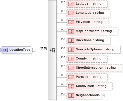
<xs:complexType name="LocationType">
    <xs:sequence>
        <xs:element name="Latitude" type="xs:string" minOccurs="0" maxOccurs="1">
            <xs:annotation>
                <xs:appinfo>
                    <retsid>101894</retsid>
                </xs:appinfo>
            </xs:annotation>
        </xs:element>
        <xs:element name="Longitude" type="xs:string" minOccurs="0" maxOccurs="1">
            <xs:annotation>
                <xs:appinfo>
                    <retsid>101895</retsid>
                </xs:appinfo>
            </xs:annotation>
        </xs:element>
        <xs:element name="Elevation" type="xs:string" minOccurs="0" maxOccurs="1">
            <xs:annotation>
                <xs:appinfo>
                    <retsid>101896</retsid>
                </xs:appinfo>
            </xs:annotation>
        </xs:element>
        <xs:element name="MapCoordinate" type="xs:string" minOccurs="0" maxOccurs="1">
            <xs:annotation>
                <xs:appinfo>
                    <retsid>101897</retsid>
                </xs:appinfo>
            </xs:annotation>
        </xs:element>
        <xs:element name="Directions" type="xs:string" minOccurs="0" maxOccurs="1">
            <xs:annotation>
                <xs:appinfo>
                    <retsid>101898</retsid>
                </xs:appinfo>
            </xs:annotation>
        </xs:element>
        <xs:element name="GeocodeOptions" type="xs:string" minOccurs="0" maxOccurs="1">
            <xs:annotation>
                <xs:appinfo>
                    <retsid>101899</retsid>
                </xs:appinfo>
            </xs:annotation>
        </xs:element>
        <xs:element name="County" type="xs:string" minOccurs="0" maxOccurs="1">
            <xs:annotation>
                <xs:appinfo>
                    <retsid>101900</retsid>
                </xs:appinfo>
            </xs:annotation>
        </xs:element>
        <xs:element name="StreetIntersection" type="xs:string" minOccurs="0" maxOccurs="1">
            <xs:annotation>
                <xs:appinfo>
                    <retsid>101901</retsid>
                </xs:appinfo>
            </xs:annotation>
        </xs:element>
        <xs:element name="ParcelId" type="xs:string" minOccurs="0" maxOccurs="1">
            <xs:annotation>
                <xs:appinfo>
                    <retsid>101902</retsid>
                </xs:appinfo>
            </xs:annotation>
        </xs:element>
        <xs:element name="Subdivision" type="xs:string" minOccurs="0" maxOccurs="1">
            <xs:annotation>
                <xs:appinfo>
                    <retsid>101903</retsid>
                </xs:appinfo>
            </xs:annotation>
        </xs:element>
        <xs:element name="Neighborhoods" minOccurs="0" maxOccurs="1">
            <xs:annotation>
                <xs:appinfo>
                    <retsid>101904</retsid>
                </xs:appinfo>
            </xs:annotation>
            <xs:complexType>
                <xs:sequence>
                    <xs:element name="Neighborhood" type="synd:NeighborhoodType" minOccurs="1" maxOccurs="unbounded">
                        <xs:annotation>
                            <xs:appinfo>
                                <retsid>101905</retsid>
                            </xs:appinfo>
                        </xs:annotation>
                    </xs:element>
                </xs:sequence>
            </xs:complexType>
        </xs:element>
    </xs:sequence>
</xs:complexType>
Collapse Child Elements:
Name Type Min Occurs Max Occurs
Latitude synd:Latitude 0 1
Longitude synd:Longitude 0 1
Elevation synd:Elevation 0 1
MapCoordinate synd:MapCoordinate 0 1
Directions synd:Directions 0 1
GeocodeOptions synd:GeocodeOptions 0 1
County synd:County 0 1
StreetIntersection synd:StreetIntersection 0 1
ParcelId synd:ParcelId 0 1
Subdivision synd:Subdivision 0 1
Neighborhoods synd:Neighborhoods 0 1
Collapse Derivation Tree:
Collapse References:
synd:Location