<complexType name="DatasetDescriptionSummaryBaseType">
<annotation>
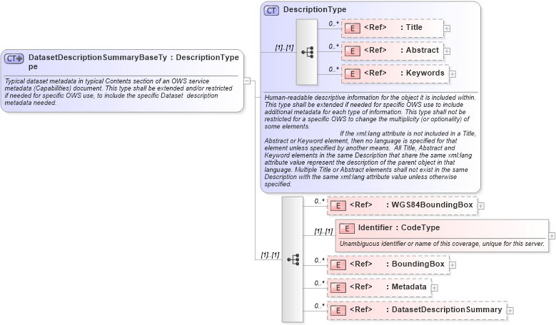
<documentation>Typical dataset metadata in typical Contents section of an OWS service metadata (Capabilities) document. This type shall be extended and/or restricted if needed for specific OWS use, to include the specific Dataset description metadata needed. </documentation>
</annotation>
<complexContent>
<extension base="ows:DescriptionType">
<sequence>
<element ref="ows:WGS84BoundingBox" minOccurs="0" maxOccurs="unbounded">
<annotation>
<documentation>Unordered list of zero or more minimum bounding rectangles surrounding coverage data, using the WGS 84 CRS with decimal degrees and longitude before latitude. If no WGS 84 bounding box is recorded for a coverage, any such bounding boxes recorded for a higher level in a hierarchy of datasets shall apply to this coverage. If WGS 84 bounding box(es) are recorded for a coverage, any such bounding boxes recorded for a higher level in a hierarchy of datasets shall be ignored. For each lowest-level coverage in a hierarchy, at least one applicable WGS84BoundingBox shall be either recorded or inherited, to simplify searching for datasets that might overlap a specified region. If multiple WGS 84 bounding boxes are included, this shall be interpreted as the union of the areas of these bounding boxes. </documentation>
</annotation>
</element>
<element name="Identifier" type="ows:CodeType">
<annotation>
<documentation>Unambiguous identifier or name of this coverage, unique for this server. </documentation>
</annotation>
</element>
<element ref="ows:BoundingBox" minOccurs="0" maxOccurs="unbounded">
<annotation>
<documentation>Unordered list of zero or more minimum bounding rectangles surrounding coverage data, in AvailableCRSs. Zero or more BoundingBoxes are allowed in addition to one or more WGS84BoundingBoxes to allow more precise specification of the Dataset area in AvailableCRSs. These Bounding Boxes shall not use any CRS not listed as an AvailableCRS. However, an AvailableCRS can be listed without a corresponding Bounding Box. If no such bounding box is recorded for a coverage, any such bounding boxes recorded for a higher level in a hierarchy of datasets shall apply to this coverage. If such bounding box(es) are recorded for a coverage, any such bounding boxes recorded for a higher level in a hierarchy of datasets shall be ignored. If multiple bounding boxes are included with the same CRS, this shall be interpreted as the union of the areas of these bounding boxes. </documentation>
</annotation>
</element>
<element ref="ows:Metadata" minOccurs="0" maxOccurs="unbounded">
<annotation>
<documentation>Optional unordered list of additional metadata about this dataset. A list of optional metadata elements for this dataset description could be specified in the Implementation Specification for this service. </documentation>
</annotation>
</element>
<element ref="ows:DatasetDescriptionSummary" minOccurs="0" maxOccurs="unbounded">
<annotation>
<documentation>Metadata describing zero or more unordered subsidiary datasets available from this server. </documentation>
</annotation>
</element>
</sequence>
</extension>
</complexContent>
</complexType>
|