Definition Type: ComplexType
Name: IdentificationType
Namespace: http://www.opengis.net/ows/1.1
Type: ows:BasicIdentificationType
Containing Schema: owsDataIdentification.xsd
Abstract
Documentation:
Extended metadata identifying and describing a set of data. This type shall be extended if needed for each specific OWS to include additional metadata for each type of dataset. If needed, this type should first be restricted for each specific OWS to change the multiplicity (or optionality) of some elements.
Collapse XSD Schema Diagram:
Drilldown into AvailableCRS in schema owsdataidentification_xsd Drilldown into OutputFormat in schema owsdataidentification_xsd Drilldown into BoundingBox in schema owscommon_xsd Drilldown into Metadata in schema owscommon_xsd Drilldown into Identifier in schema owsdataidentification_xsd Drilldown into Keywords in schema ows19115subset_xsd Drilldown into Abstract in schema ows19115subset_xsd Drilldown into Title in schema ows19115subset_xsd Drilldown into DescriptionType in schema owsdataidentification_xsd Drilldown into BasicIdentificationType in schema owsdataidentification_xsdXSD Diagram of IdentificationType in schema owsdataidentification_xsd (OGC Web Feature Service)
Collapse XSD Schema Code:
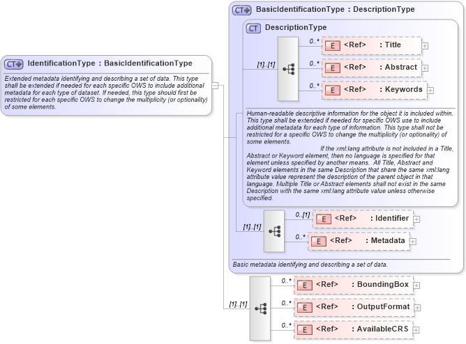
<complexType name="IdentificationType">
    <annotation>
        <documentation>Extended metadata identifying and describing a set of data. This type shall be extended if needed for each specific OWS to include additional metadata for each type of dataset. If needed, this type should first be restricted for each specific OWS to change the multiplicity (or optionality) of some elements. </documentation>
    </annotation>
    <complexContent>
        <extension base="ows:BasicIdentificationType">
            <sequence>
                <element ref="ows:BoundingBox" minOccurs="0" maxOccurs="unbounded">
                    <annotation>
                        <documentation>Unordered list of zero or more bounding boxes whose union describes the extent of this dataset. </documentation>
                    </annotation>
                </element>
                <element ref="ows:OutputFormat" minOccurs="0" maxOccurs="unbounded">
                    <annotation>
                        <documentation>Unordered list of zero or more references to data formats supported for server outputs. </documentation>
                    </annotation>
                </element>
                <element ref="ows:AvailableCRS" minOccurs="0" maxOccurs="unbounded">
                    <annotation>
                        <documentation>Unordered list of zero or more available coordinate reference systems. </documentation>
                    </annotation>
                </element>
            </sequence>
        </extension>
    </complexContent>
</complexType>
Collapse Child Elements:
Name Type Min Occurs Max Occurs
Title ows:Title 0 unbounded
Abstract ows:Abstract 0 unbounded
Keywords ows:Keywords 0 unbounded
Identifier ows:Identifier 0 (1)
Metadata ows:Metadata 0 unbounded
BoundingBox ows:BoundingBox 0 unbounded
OutputFormat ows:OutputFormat 0 unbounded
AvailableCRS ows:AvailableCRS 0 unbounded
Collapse Derivation Tree: