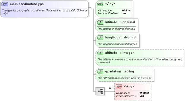
<xs:complexType name="GeoCoordinatesType">
    <xs:annotation>
        <xs:documentation>The type for geographic coordinates (Type defined in this XML Schema only)</xs:documentation>
    </xs:annotation>
    <xs:sequence>
        <xs:any namespace="##other" processContents="lax" minOccurs="0" maxOccurs="unbounded" />
    </xs:sequence>
    <xs:attribute name="latitude" type="xs:decimal" use="required">
        <xs:annotation>
            <xs:documentation>The latitude in decimal degrees.</xs:documentation>
        </xs:annotation>
    </xs:attribute>
    <xs:attribute name="longitude" type="xs:decimal" use="required">
        <xs:annotation>
            <xs:documentation>The longitude in decimal degrees.</xs:documentation>
        </xs:annotation>
    </xs:attribute>
    <xs:attribute name="altitude" type="xs:integer">
        <xs:annotation>
            <xs:documentation>The altitude in meters above the zero elevation of the reference system (sea level).</xs:documentation>
        </xs:annotation>
    </xs:attribute>
    <xs:attribute name="gpsdatum" type="xs:string">
        <xs:annotation>
            <xs:documentation>The GPS datum associated with the measure.</xs:documentation>
        </xs:annotation>
    </xs:attribute>
    <xs:anyAttribute namespace="##other" processContents="lax" />
</xs:complexType>
|