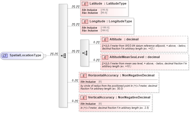
<xsd:complexType name="SpatialLocationType">
    <xsd:sequence>
        <xsd:element name="Latitude" type="LatitudeType" />
        <xsd:element name="Longitude" type="LongitudeType" />
        <xsd:choice>
            <xsd:element name="Altitude" type="xsd:decimal" minOccurs="0">
                <xsd:annotation>
                    <xsd:documentation>[(+)|-]x.f meter from WGS-84 datum reference ellipsoid, + above, - below, decimal fraction f in arbitrary length (ex. +12 )</xsd:documentation>
                </xsd:annotation>
            </xsd:element>
            <xsd:element name="AltitudeMeanSeaLevel" type="xsd:decimal" minOccurs="0">
                <xsd:annotation>
                    <xsd:documentation>[(+)|-]x.f meter from mean sea level, + above, - below, decimal fraction f in arbitrary length (ex. +10 )</xsd:documentation>
                </xsd:annotation>
            </xsd:element>
        </xsd:choice>
        <xsd:element name="HorizontalAccuracy" type="NonNegativeDecimal" minOccurs="0">
            <xsd:annotation>
                <xsd:documentation>by circle of radius from the positioned point in (+)x.f meter, decimal fraction f in arbitrary length (ex. 50.0)</xsd:documentation>
            </xsd:annotation>
        </xsd:element>
        <xsd:element name="VerticalAccuracy" type="NonNegativeDecimal" minOccurs="0">
            <xsd:annotation>
                <xsd:documentation>in (+)x.f meter, decimal fraction f in arbitrary length (ex. 2.5)</xsd:documentation>
            </xsd:annotation>
        </xsd:element>
    </xsd:sequence>
</xsd:complexType>
|