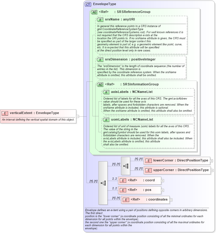
Definition Type: Element
Name: verticalExtent
Namespace: http://www.opengis.net/gml
Type: gml:EnvelopeType
Containing Schema: referenceSystems.xsd
Abstract
Documentation:
An interval defining the vertical spatial domain of this object.
Collapse XSD Schema Diagram:
Drilldown into coordinates in schema geometrybasic0d1d_xsd Drilldown into pos in schema geometrybasic0d1d_xsd Drilldown into coord in schema geometrybasic0d1d_xsd Drilldown into upperCorner in schema geometrybasic0d1d_xsd Drilldown into lowerCorner in schema geometrybasic0d1d_xsd Drilldown into uomLabels in schema geometrybasic0d1d_xsd Drilldown into axisLabels in schema geometrybasic0d1d_xsd Drilldown into SRSInformationGroup in schema geometrybasic0d1d_xsd Drilldown into srsDimension in schema geometrybasic0d1d_xsd Drilldown into srsName in schema geometrybasic0d1d_xsd Drilldown into SRSReferenceGroup in schema geometrybasic0d1d_xsd Drilldown into EnvelopeType in schema geometrybasic0d1d_xsdXSD Diagram of verticalExtent in schema referencesystems_xsd (Geography Markup Language)
Collapse XSD Schema Code:
<element name="verticalExtent" type="gml:EnvelopeType">
    <annotation>
        <documentation>An interval defining the vertical spatial domain of this object.</documentation>
    </annotation>
</element>
Collapse Child Elements:
Name Type Min Occurs Max Occurs
lowerCorner gml:lowerCorner (1) (1)
upperCorner gml:upperCorner (1) (1)
coord gml:coord 2 2
pos gml:pos 2 2
coordinates gml:coordinates (1) (1)
Collapse Child Attributes:
Name Type Default Value Use
srsName gml:srsName Optional
srsDimension gml:srsDimension Optional
axisLabels gml:axisLabels Optional
uomLabels gml:uomLabels Optional
Collapse Derivation Tree: