<xs:element name="CrossSectSurf">
<xs:annotation>
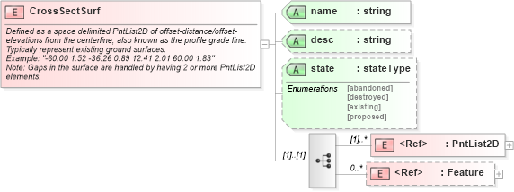
<xs:documentation>Defined as a space delimited PntList2D of offset-distance/offset-elevations from the centerline, also known as the profile grade line. Typically represent existing ground surfaces.</xs:documentation>
<xs:documentation>Example: "-60.00 1.52 -36.26 0.89 12.41 2.01 60.00 1.83"</xs:documentation>
<xs:documentation>Note: Gaps in the surface are handled by having 2 or more PntList2D elements.</xs:documentation>
</xs:annotation>
<xs:complexType>
<xs:sequence>
<xs:element ref="PntList2D" maxOccurs="unbounded" />
<xs:element ref="Feature" minOccurs="0" maxOccurs="unbounded" />
</xs:sequence>
<xs:attribute name="name" type="xs:string" use="required" />
<xs:attribute name="desc" type="xs:string" />
<xs:attribute name="state" type="stateType" />
</xs:complexType>
</xs:element>
|