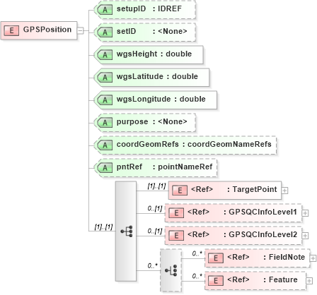
<xs:element name="GPSPosition">
    <xs:annotation>
        <xs:documentation />
    </xs:annotation>
    <xs:complexType>
        <xs:sequence>
            <xs:element ref="TargetPoint" />
            <xs:element ref="GPSQCInfoLevel1" minOccurs="0" />
            <xs:element ref="GPSQCInfoLevel2" minOccurs="0" />
            <xs:choice minOccurs="0" maxOccurs="unbounded">
                <xs:element ref="FieldNote" minOccurs="0" maxOccurs="unbounded" />
                <xs:element ref="Feature" minOccurs="0" maxOccurs="unbounded" />
            </xs:choice>
        </xs:sequence>
        <xs:attribute name="setupID" type="xs:IDREF" />
        <xs:attribute name="setID" />
        <xs:attribute name="wgsHeight" type="xs:double" use="required" />
        <xs:attribute name="wgsLatitude" type="xs:double" use="required" />
        <xs:attribute name="wgsLongitude" type="xs:double" use="required" />
        <xs:attribute name="purpose" />
        <xs:attribute name="coordGeomRefs" type="coordGeomNameRefs" />
        <xs:attribute name="pntRef" type="pointNameRef" />
        <!-- coordGeomRefs identifies one or more 'name' values that link to specific <Line>, <Curve>, <Spiral> or <IrregularLine> in a <CoordGeom> element. This allows linking an survey observation to specific <Parcel>.<CoordGeom> based geometry. -->
    </xs:complexType>
</xs:element>
|