<xs:element name="Watershed">
<xs:annotation>
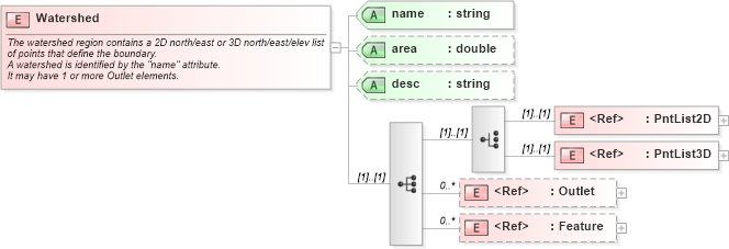
<xs:documentation>The watershed region contains a 2D north/east or 3D north/east/elev list of points that define the boundary.</xs:documentation>
<xs:documentation>A watershed is identified by the "name" attribute.</xs:documentation>
<xs:documentation>It may have 1 or more Outlet elements.</xs:documentation>
</xs:annotation>
<xs:complexType>
<xs:sequence>
<xs:choice>
<xs:element ref="PntList2D" />
<xs:element ref="PntList3D" />
<!-- Here PntList2D represents 2D planametric coordinate pairs expressed as space delimited Northing Easting pairs. -->
</xs:choice>
<xs:element ref="Outlet" minOccurs="0" maxOccurs="unbounded" />
<xs:element ref="Feature" minOccurs="0" maxOccurs="unbounded" />
</xs:sequence>
<xs:attribute name="name" type="xs:string" use="required" />
<xs:attribute name="area" type="xs:double" />
<xs:attribute name="desc" type="xs:string" />
</xs:complexType>
</xs:element>
|