Definition Type: Element
Name: GeographicData
Namespace: http://rets.org/xsd/Properties/2007-08
Type: commons:GeographicData
Containing Schema: Properties.xsd
MinOccurs 0
MaxOccurs (1)
Abstract
Collapse XSD Schema Diagram:
Drilldown into CoordinateSystem in schema retscommons_xsd Drilldown into PrintedMapCoordinates in schema retscommons_xsd Drilldown into FloodPlain in schema retscommons_xsd Drilldown into CensusGeography in schema retscommons_xsd Drilldown into CrossStreet in schema retscommons_xsd Drilldown into URL in schema retscommons_xsd Drilldown into Accuracy in schema retscommons_xsd Drilldown into Source in schema retscommons_xsd Drilldown into Directions in schema retscommons_xsd Drilldown into MapCoordinate in schema retscommons_xsd Drilldown into Elevation in schema retscommons_xsd Drilldown into Longitude in schema retscommons_xsd Drilldown into Latitude in schema retscommons_xsd Drilldown into SimpleGeographicData in schema retscommons_xsd Drilldown into GeographicData in schema retscommons_xsdXSD Diagram of GeographicData in schema properties_xsd (Real Estate Transaction Standard (RETS))
Collapse XSD Schema Code:
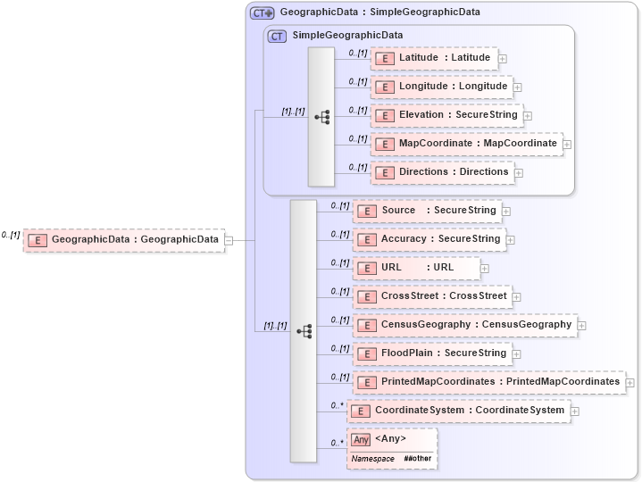
<xs:element name="GeographicData" type="commons:GeographicData" minOccurs="0">
    <xs:annotation>
        <xs:documentation>
        </xs:documentation>
        <xs:appinfo>
            <retsid>
            </retsid>
        </xs:appinfo>
    </xs:annotation>
</xs:element>
Collapse Child Elements:
Name Type Min Occurs Max Occurs
Latitude commons:Latitude 0 (1)
Longitude commons:Longitude 0 (1)
Elevation commons:Elevation 0 (1)
MapCoordinate commons:MapCoordinate 0 (1)
Directions commons:Directions 0 (1)
Source commons:Source 0 (1)
Accuracy commons:Accuracy 0 (1)
URL commons:URL 0 (1)
CrossStreet commons:CrossStreet 0 (1)
CensusGeography commons:CensusGeography 0 (1)
FloodPlain commons:FloodPlain 0 (1)
PrintedMapCoordinates commons:PrintedMapCoordinates 0 (1)
CoordinateSystem commons:CoordinateSystem 0 unbounded
<xs:any> Allowed namespace: '##other' 0 unbounded
Collapse Derivation Tree: