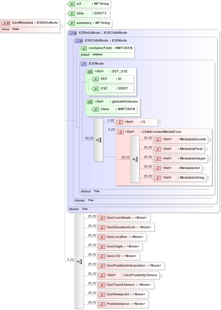
<xs:element name="GeoMetadata">
    <xs:annotation>
        <xs:appinfo />
        <xs:documentation source="http://www.web3d.org/x3d/specifications/ISO-IEC-FDIS-19775-1.2-X3D-AbstractSpecification/Part01/components/geodata.html#GeoMetadata" />
    </xs:annotation>
    <xs:complexType mixed="false">
        <xs:complexContent mixed="false">
            <xs:extension base="X3DInfoNode">
                <xs:choice minOccurs="0">
                    <xs:element name="GeoCoordinate" />
                    <xs:element name="GeoElevationGrid" />
                    <xs:element name="GeoLocation" />
                    <xs:element name="GeoOrigin" />
                    <xs:element name="GeoLOD" />
                    <!--	<xs:element name="GeoMetadata"/> excluded since does not make sense for a GeoMetadata node to pertain to another GeoMetadata node -->
                    <xs:element name="GeoPositionInterpolator" />
                    <xs:element ref="GeoProximitySensor" />
                    <xs:element name="GeoTouchSensor" />
                    <xs:element name="GeoViewpoint" />
                    <xs:element name="ProtoInstance" />
                </xs:choice>
                <xs:attribute name="url" type="MFString" />
                <xs:attribute name="data" type="xs:IDREFS" />
                <xs:attribute name="summary" type="MFString" />
            </xs:extension>
            <!--
					<xs:attribute name="title" type="SFString"/>
					<xs:attribute name="description" type="SFString"/>
					<xs:attribute name="coordinateSystem" type="SFString"/>
					<xs:attribute name="horizontalDatum" type="SFString"/>
					<xs:attribute name="verticalDatum" type="SFString"/>
					<xs:attribute name="ellipsoid" type="SFString"/>
					<xs:attribute name="extent" type="SFString"/>
					<xs:attribute name="resolution" type="SFString"/>
					<xs:attribute name="originator" type="SFString"/>
					<xs:attribute name="copyright" type="SFString"/>
					<xs:attribute name="date" type="SFString"/>
					<xs:attribute name="metadataFormat" type="SFString"/>
					<xs:attribute name="dataUrl" type="SFString"/>
					<xs:attribute name="dataFormat" type="SFString"/>
					-->
            <!-- 'data' field is MFNode reference array to pertinent GeoSpatial nodes affected by this GeoMetadata node, empty array refers to entire scene -->
        </xs:complexContent>
    </xs:complexType>
</xs:element>
|