<xsd:complexType name="AbstractDatumType" abstract="true" xmlns:xsd="http://www.w3.org/2001/XMLSchema">
<xsd:annotation>
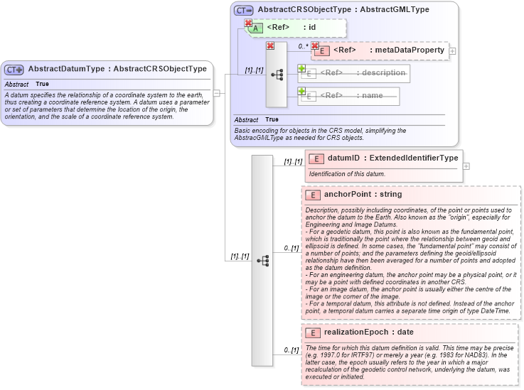
<xsd:documentation>A datum specifies the relationship of a coordinate system to the earth, thus creating a coordinate reference system. A datum uses a parameter or set of parameters that determine the location of the origin, the orientation, and the scale of a coordinate reference system. </xsd:documentation>
</xsd:annotation>
<xsd:complexContent>
<xsd:extension base="gml:AbstractCRSObjectType">
<xsd:sequence>
<xsd:element name="datumID" type="gml:ExtendedIdentifierType">
<xsd:annotation>
<xsd:documentation>Identification of this datum. </xsd:documentation>
</xsd:annotation>
</xsd:element>
<xsd:element name="anchorPoint" type="string" minOccurs="0">
<xsd:annotation>
<xsd:documentation>Description, possibly including coordinates, of the point or points used to anchor the datum to the Earth. Also known as the "origin", especially for Engineering and Image Datums.
- For a geodetic datum, this point is also known as the fundamental point, which is traditionally the point where the relationship between geoid and ellipsoid is defined. In some cases, the "fundamental point" may consist of a number of points; and the parameters defining the geoid/ellipsoid relationship have then been averaged for a number of points and adopted as the datum definition.
- For an engineering datum, the anchor point may be a physical point, or it may be a point with defined coordinates in another CRS.
- For an image datum, the anchor point is usually either the centre of the image or the corner of the image.
- For a temporal datum, this attribute is not defined. Instead of the anchor point, a temporal datum carries a separate time origin of type DateTime. </xsd:documentation>
</xsd:annotation>
</xsd:element>
<xsd:element name="realizationEpoch" type="date" minOccurs="0">
<xsd:annotation>
<xsd:documentation>The time for which this datum definition is valid. This time may be precise (e.g. 1997.0 for IRTF97) or merely a year (e.g. 1983 for NAD83). In the latter case, the epoch usually refers to the year in which a major recalculation of the geodetic control network, underlying the datum, was executed or initiated. </xsd:documentation>
</xsd:annotation>
</xsd:element>
</xsd:sequence>
</xsd:extension>
</xsd:complexContent>
</xsd:complexType>
|