Definition Type: ComplexType
Name: VerticalCRSType
Namespace: http://www.opengis.net/gml
Type: gml:AbstractCoordinateReferenceSystemType
Containing Schema: coordinateReferenceSystems.xsd
Abstract
Documentation:
A 1D coordinate reference system used for recording heights or depths. Vertical CRSs make use of the direction of gravity to define the concept of height or depth, but the relationship with gravity may not be straightforward. By implication, ellipsoidal heights (h) cannot be captured in a vertical coordinate reference system. Ellipsoidal heights cannot exist independently, but only as inseparable part of a 3D coordinate tuple defined in a geographic 3D coordinate reference system.
Collapse XSD Schema Diagram:
Drilldown into usesVerticalDatum in schema coordinatereferencesystems_xsd Drilldown into usesVerticalCS in schema coordinatereferencesystems_xsd Drilldown into scope in schema referencesystems_xsd Drilldown into validArea in schema referencesystems_xsd Drilldown into srsID in schema referencesystems_xsd Drilldown into srsName in schema referencesystems_xsd Drilldown into remarks in schema referencesystems_xsd Drilldown into name in schema gmlbase_xsd Drilldown into description in schema gmlbase_xsd Drilldown into metaDataProperty in schema gmlbase_xsd Drilldown into id in schema gmlbase_xsd Drilldown into AbstractReferenceSystemBaseType in schema referencesystems_xsd Drilldown into AbstractReferenceSystemType in schema referencesystems_xsd Drilldown into AbstractCRSType in schema referencesystems_xsd Drilldown into AbstractCoordinateReferenceSystemType in schema coordinatereferencesystems_xsdXSD Diagram of VerticalCRSType in schema coordinatereferencesystems_xsd (Geography Markup Language)
Collapse XSD Schema Code:
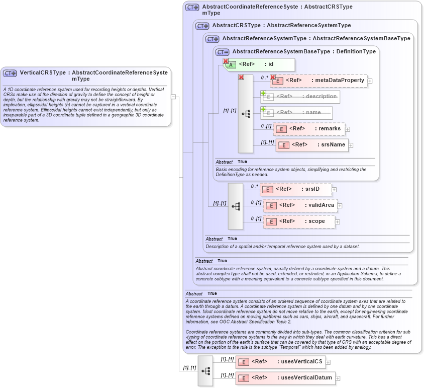
<complexType name="VerticalCRSType">
    <annotation>
        <documentation>A 1D coordinate reference system used for recording heights or depths. Vertical CRSs make use of the direction of gravity to define the concept of height or depth, but the relationship with gravity may not be straightforward. By implication, ellipsoidal heights (h) cannot be captured in a vertical coordinate reference system. Ellipsoidal heights cannot exist independently, but only as inseparable part of a 3D coordinate tuple defined in a geographic 3D coordinate reference system. </documentation>
    </annotation>
    <complexContent>
        <extension base="gml:AbstractCoordinateReferenceSystemType">
            <sequence>
                <element ref="gml:usesVerticalCS" />
                <element ref="gml:usesVerticalDatum" />
            </sequence>
        </extension>
    </complexContent>
</complexType>
Collapse Child Elements:
Name Type Min Occurs Max Occurs
metaDataProperty gml:metaDataProperty 0 unbounded
description gml:description 0 (1)
name gml:name 0 unbounded
metaDataProperty gml:metaDataProperty 0 unbounded
description gml:description 0 (1)
name gml:name (1) unbounded
metaDataProperty gml:metaDataProperty 0 unbounded
remarks gml:remarks 0 (1)
srsName gml:srsName (1) (1)
srsID gml:srsID 0 unbounded
validArea gml:validArea 0 (1)
scope gml:scope 0 (1)
usesVerticalCS gml:usesVerticalCS (1) (1)
usesVerticalDatum gml:usesVerticalDatum (1) (1)
Collapse Child Attributes:
Name Type Default Value Use
id gml:id Required
Collapse Derivation Tree:
Collapse References:
gml:VerticalCRS