Definition Type: Element
Name: SurveyHeader
Namespace: http://www.landxml.org/schema/LandXML-1.1
Containing Schema: LandXML-1.1.xsd
Abstract
Documentation:
We seemed to have doubled up on the survey purpose here, but the two are quite different - maybe need a different name
Collapse XSD Schema Diagram:
Drilldown into SurveyorCertificate in schema landxml-1_1_xsd Drilldown into Feature in schema landxml-1_1_xsd Drilldown into FieldNote in schema landxml-1_1_xsd Drilldown into Personnel in schema landxml-1_1_xsd Drilldown into MapPoint in schema landxml-1_1_xsd Drilldown into Units in schema landxml-1_1_xsd Drilldown into CoordinateSystem in schema landxml-1_1_xsd Drilldown into AdministrativeDate in schema landxml-1_1_xsd Drilldown into AdministrativeArea in schema landxml-1_1_xsd Drilldown into Annotation in schema landxml-1_1_xsd Drilldown into fieldReport in schema landxml-1_1_xsd Drilldown into fieldNoteReference in schema landxml-1_1_xsd Drilldown into fieldNoteFlag in schema landxml-1_1_xsd Drilldown into communityTitleSchemeName in schema landxml-1_1_xsd Drilldown into communityTitleSchemeNo in schema landxml-1_1_xsd Drilldown into surveyStatus in schema landxml-1_1_xsd Drilldown into surveyFormat in schema landxml-1_1_xsd Drilldown into headOfPower in schema landxml-1_1_xsd Drilldown into documentStatus in schema landxml-1_1_xsd Drilldown into submissionDate in schema landxml-1_1_xsd Drilldown into jurisdiction in schema landxml-1_1_xsd Drilldown into combinedFactor in schema landxml-1_1_xsd Drilldown into seaLevelCorrectionFactor in schema landxml-1_1_xsd Drilldown into scaleFactor in schema landxml-1_1_xsd Drilldown into applySeaLevelCorrection in schema landxml-1_1_xsd Drilldown into temperature in schema landxml-1_1_xsd Drilldown into pressure in schema landxml-1_1_xsd Drilldown into applyAtmosphericCorrection in schema landxml-1_1_xsd Drilldown into county in schema landxml-1_1_xsd Drilldown into class in schema landxml-1_1_xsd Drilldown into type in schema landxml-1_1_xsd Drilldown into surveyPurpose in schema landxml-1_1_xsd Drilldown into surveyorRegistration in schema landxml-1_1_xsd Drilldown into surveyorReference in schema landxml-1_1_xsd Drilldown into surveyorFirm in schema landxml-1_1_xsd Drilldown into surveyor in schema landxml-1_1_xsd Drilldown into endTime in schema landxml-1_1_xsd Drilldown into startTime in schema landxml-1_1_xsd Drilldown into purpose in schema landxml-1_1_xsd Drilldown into desc in schema landxml-1_1_xsd Drilldown into name in schema landxml-1_1_xsdXSD Diagram of SurveyHeader in schema landxml-1_1_xsd (National Information Exchange Model (NEIM))
Collapse XSD Schema Code:
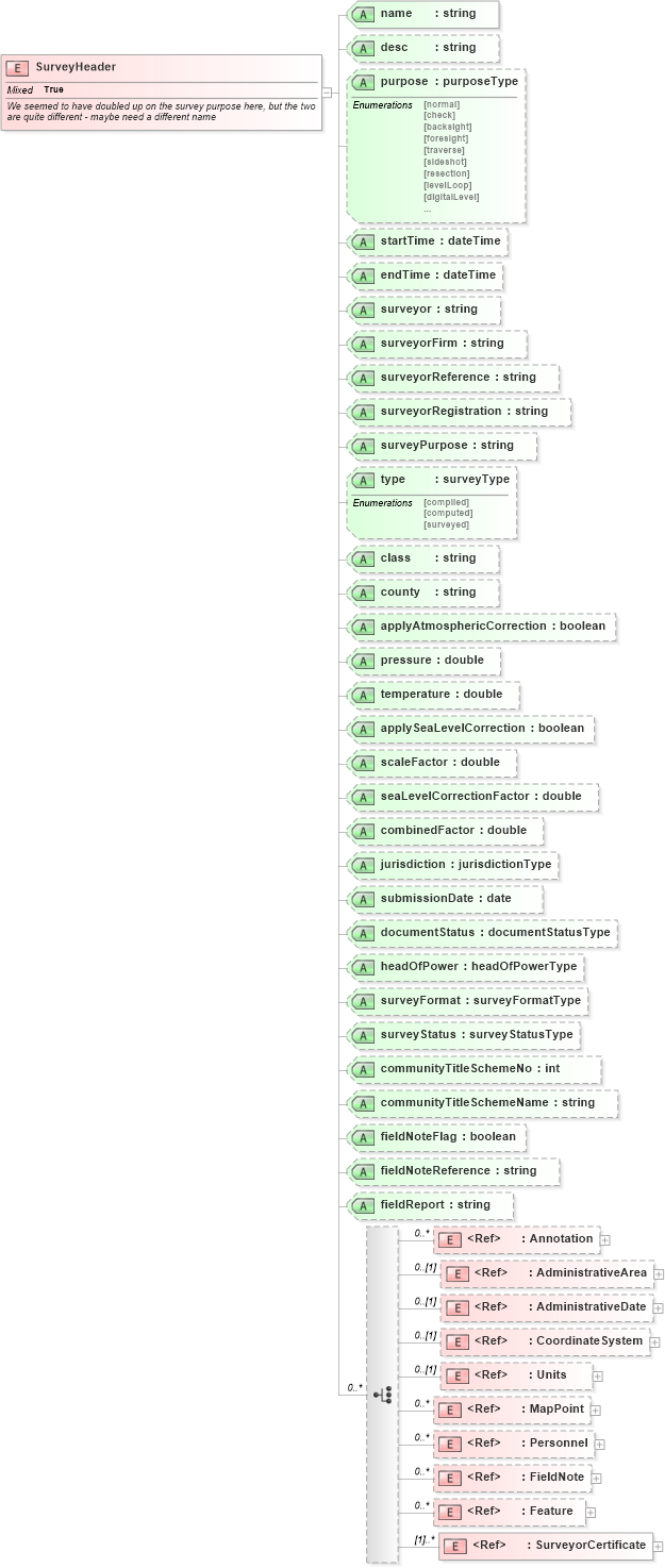
<xs:element name="SurveyHeader">
    <xs:annotation>
        <xs:documentation>We seemed to have doubled up on the survey purpose here, but the two are quite different - maybe need a different name</xs:documentation>
    </xs:annotation>
    <xs:complexType mixed="true">
        <xs:choice minOccurs="0" maxOccurs="unbounded">
            <xs:element ref="Annotation" minOccurs="0" maxOccurs="unbounded" />
            <xs:element ref="AdministrativeArea" minOccurs="0" />
            <xs:element ref="AdministrativeDate" minOccurs="0" />
            <xs:element ref="CoordinateSystem" minOccurs="0" />
            <xs:element ref="Units" minOccurs="0" />
            <xs:element ref="MapPoint" minOccurs="0" maxOccurs="unbounded" />
            <xs:element ref="Personnel" minOccurs="0" maxOccurs="unbounded" />
            <xs:element ref="FieldNote" minOccurs="0" maxOccurs="unbounded" />
            <xs:element ref="Feature" minOccurs="0" maxOccurs="unbounded" />
            <xs:element ref="SurveyorCertificate" maxOccurs="unbounded" />
        </xs:choice>
        <xs:attribute name="name" type="xs:string" use="required" />
        <xs:attribute name="desc" type="xs:string" />
        <xs:attribute name="purpose" type="purposeType" />
        <xs:attribute name="startTime" type="xs:dateTime" />
        <xs:attribute name="endTime" type="xs:dateTime" />
        <xs:attribute name="surveyor" type="xs:string" />
        <xs:attribute name="surveyorFirm" type="xs:string" />
        <xs:attribute name="surveyorReference" type="xs:string" />
        <xs:attribute name="surveyorRegistration" type="xs:string" />
        <xs:attribute name="surveyPurpose" type="xs:string" />
        <xs:attribute name="type" type="surveyType" />
        <xs:attribute name="class" type="xs:string" />
        <xs:attribute name="county" type="xs:string" />
        <xs:attribute name="applyAtmosphericCorrection" type="xs:boolean" />
        <xs:attribute name="pressure" type="xs:double" />
        <xs:attribute name="temperature" type="xs:double" />
        <xs:attribute name="applySeaLevelCorrection" type="xs:boolean" />
        <xs:attribute name="scaleFactor" type="xs:double" />
        <xs:attribute name="seaLevelCorrectionFactor" type="xs:double" />
        <xs:attribute name="combinedFactor" type="xs:double" />
        <xs:attribute name="jurisdiction" type="jurisdictionType" />
        <xs:attribute name="submissionDate" type="xs:date" />
        <xs:attribute name="documentStatus" type="documentStatusType" />
        <xs:attribute name="headOfPower" type="headOfPowerType" />
        <xs:attribute name="surveyFormat" type="surveyFormatType" />
        <xs:attribute name="surveyStatus" type="surveyStatusType" />
        <xs:attribute name="communityTitleSchemeNo" type="xs:int" />
        <xs:attribute name="communityTitleSchemeName" type="xs:string" />
        <xs:attribute name="fieldNoteFlag" type="xs:boolean" />
        <xs:attribute name="fieldNoteReference" type="xs:string" />
        <xs:attribute name="fieldReport" type="xs:string" />
    </xs:complexType>
</xs:element>
Collapse Child Elements:
Name Type Min Occurs Max Occurs
Annotation land:Annotation 0 unbounded
AdministrativeArea land:AdministrativeArea 0 (1)
AdministrativeDate land:AdministrativeDate 0 (1)
CoordinateSystem land:CoordinateSystem 0 (1)
Units land:Units 0 (1)
MapPoint land:MapPoint 0 unbounded
Personnel land:Personnel 0 unbounded
FieldNote land:FieldNote 0 unbounded
Feature land:Feature 0 unbounded
SurveyorCertificate land:SurveyorCertificate (1) unbounded
Collapse Child Attributes:
Name Type Default Value Use
name land:name Required
desc land:desc (Optional)
purpose land:purpose (Optional)
startTime land:startTime (Optional)
endTime land:endTime (Optional)
surveyor land:surveyor (Optional)
surveyorFirm land:surveyorFirm (Optional)
surveyorReference land:surveyorReference (Optional)
surveyorRegistration land:surveyorRegistration (Optional)
surveyPurpose land:surveyPurpose (Optional)
type land:type (Optional)
class land:class (Optional)
county land:county (Optional)
applyAtmosphericCorrection land:applyAtmosphericCorrection (Optional)
pressure land:pressure (Optional)
temperature land:temperature (Optional)
applySeaLevelCorrection land:applySeaLevelCorrection (Optional)
scaleFactor land:scaleFactor (Optional)
seaLevelCorrectionFactor land:seaLevelCorrectionFactor (Optional)
combinedFactor land:combinedFactor (Optional)
jurisdiction land:jurisdiction (Optional)
submissionDate land:submissionDate (Optional)
documentStatus land:documentStatus (Optional)
headOfPower land:headOfPower (Optional)
surveyFormat land:surveyFormat (Optional)
surveyStatus land:surveyStatus (Optional)
communityTitleSchemeNo land:communityTitleSchemeNo (Optional)
communityTitleSchemeName land:communityTitleSchemeName (Optional)
fieldNoteFlag land:fieldNoteFlag (Optional)
fieldNoteReference land:fieldNoteReference (Optional)
fieldReport land:fieldReport (Optional)