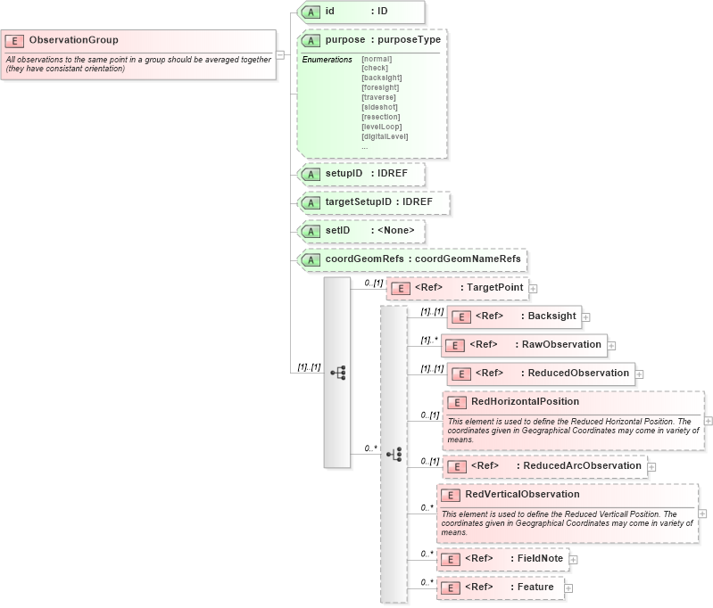
<xs:element name="ObservationGroup">
    <xs:annotation>
        <xs:documentation>All observations to the same point in a group should be averaged together (they have consistant orientation)</xs:documentation>
    </xs:annotation>
    <xs:complexType>
        <xs:sequence>
            <xs:element ref="TargetPoint" minOccurs="0" />
            <xs:choice minOccurs="0" maxOccurs="unbounded">
                <xs:element ref="Backsight" />
                <xs:element ref="RawObservation" maxOccurs="unbounded" />
                <xs:element ref="ReducedObservation" />
                <xs:element name="RedHorizontalPosition" minOccurs="0">
                    <xs:annotation>
                        <xs:documentation>This element is used to define the Reduced Horizontal Position. The coordinates given in Geographical Coordinates may come in variety of means.</xs:documentation>
                    </xs:annotation>
                    <xs:complexType>
                        <xs:sequence>
                            <xs:element ref="FieldNote" />
                        </xs:sequence>
                        <xs:attribute name="desc" type="xs:string" />
                        <xs:attribute name="name" type="xs:string" />
                        <xs:attribute name="state" type="xs:string" />
                        <xs:attribute name="oID" type="xs:string" />
                        <xs:attribute name="purpose" type="xs:string" />
                        <xs:attribute name="date" type="xs:date" />
                        <xs:attribute name="equipmentUsed" type="xs:string" />
                        <xs:attribute name="filedNote" type="xs:string" />
                        <xs:attribute name="horizontalDatum" type="xs:string" />
                        <xs:attribute name="latitude" type="xs:double" />
                        <xs:attribute name="longitude" type="xs:double" />
                        <xs:attribute name="horizontaladjustment" type="xs:string" />
                        <xs:attribute name="currencyDate" type="xs:date" />
                        <xs:attribute name="class" type="xs:integer" />
                        <xs:attribute name="positionalUncertainity" type="xs:double" />
                        <xs:attribute name="localUncertainity" type="xs:double" />
                    </xs:complexType>
                </xs:element>
                <xs:element ref="ReducedArcObservation" minOccurs="0" />
                <xs:element name="RedVerticalObservation" minOccurs="0" maxOccurs="unbounded">
                    <xs:annotation>
                        <xs:documentation>This element is used to define the Reduced Verticall Position. The coordinates given in Geographical Coordinates may come in variety of means.</xs:documentation>
                    </xs:annotation>
                    <xs:complexType>
                        <xs:sequence>
                            <xs:element ref="FieldNote" />
                        </xs:sequence>
                        <xs:attribute name="desc" type="xs:string" />
                        <xs:attribute name="name" type="xs:string" />
                        <xs:attribute name="state" type="xs:string" />
                        <xs:attribute name="oID" type="xs:string" />
                        <xs:attribute name="purpose" type="xs:string" />
                        <xs:attribute name="date" type="xs:date" />
                        <xs:attribute name="equipmentUsed" type="xs:string" />
                        <xs:attribute name="filedNote" type="xs:string" />
                        <xs:attribute name="currencyDate" type="xs:date" />
                        <xs:attribute name="class" type="xs:integer" />
                        <xs:attribute name="positionalUncertainity" type="xs:string" />
                        <xs:attribute name="localUncertainity" type="xs:string" />
                        <xs:attribute name="order" type="xs:string" />
                        <xs:attribute name="verticalDatum" type="xs:string" />
                        <xs:attribute name="height" type="xs:double" />
                        <xs:attribute name="verticalAdjustment" type="xs:string" />
                    </xs:complexType>
                </xs:element>
                <xs:element ref="FieldNote" minOccurs="0" maxOccurs="unbounded" />
                <xs:element ref="Feature" minOccurs="0" maxOccurs="unbounded" />
            </xs:choice>
        </xs:sequence>
        <xs:attribute name="id" type="xs:ID" use="required" />
        <xs:attribute name="purpose" type="purposeType" />
        <xs:attribute name="setupID" type="xs:IDREF" />
        <xs:attribute name="targetSetupID" type="xs:IDREF" />
        <xs:attribute name="setID" />
        <xs:attribute name="coordGeomRefs" type="coordGeomNameRefs" />
        <!-- coordGeomRefs identifies one or more 'name' values that link to specific <Line>, <Curve>, <Spiral> or <IrregularLine> in a <CoordGeom> element. This allows linking an survey observation to specific <Parcel>.<CoordGeom> based geometry. -->
    </xs:complexType>
</xs:element>
|