Definition Type: ComplexType
Name: AbstractCoordinateReferenceSystemType
Namespace: http://www.opengis.net/gml
Type: gml:AbstractCRSType
Containing Schema: coordinateReferenceSystems.xsd
Abstract True
Documentation:
A coordinate reference system consists of a set of coordinate system axes that is related to the earth through a datum. A coordinate reference system is realised by a set of coordinates. A coordinate reference system is defined by one datum and by one coordinate system. For the purposes of this specification, a coordinate reference system shall not change with time with the exception of engineering coordinate reference systems defined on moving platforms such as cars, ships, aircraft, and spacecraft. The intention is to exclude the option to describe the time variability of geodetic coordinate reference systems as a result of e.g. tectonic motion. This variability is part of the subject matter of geophysical and geodetic science. The model for spatial referencing by coordinates described in this Abstract Specification is in principle not suitable for such zero-order geodetic problems. Such time-variability of coordinate reference systems shall be covered in the spatial referencing model described in this document by creating different coordinate reference systems each with a different datum for (consecutive) epochs. The date of realisation of the datum shall be included in its definition. It is further recommended to include the date of realisation also in the names of the datums and the coordinate reference systems. Coordinate reference systems are commonly divided into sub-types. The common classification criterion for sub-typing of coordinate reference systems is the way in which they deal with earth curvature. This has a direct effect on the portion of the earth's surface that can be covered by that type of CRS with an acceptable degree of error. The exception to the rule is the subtype "Temporal" which has been added by analogy.
Collapse XSD Schema Diagram:
Drilldown into crsID in schema referencesystems_xsd Drilldown into name in schema gmlbase_xsd Drilldown into description in schema gmlbase_xsd Drilldown into metaDataProperty in schema gmlbase_xsd Drilldown into id in schema gmlbase_xsd Drilldown into AbstractCRSObjectType in schema referencesystems_xsd Drilldown into AbstractReferenceSystemType in schema referencesystems_xsd Drilldown into AbstractCRSType in schema referencesystems_xsdXSD Diagram of AbstractCoordinateReferenceSystemType in schema coordinatereferencesystems_xsd (Geography Markup Language)
Collapse XSD Schema Code:
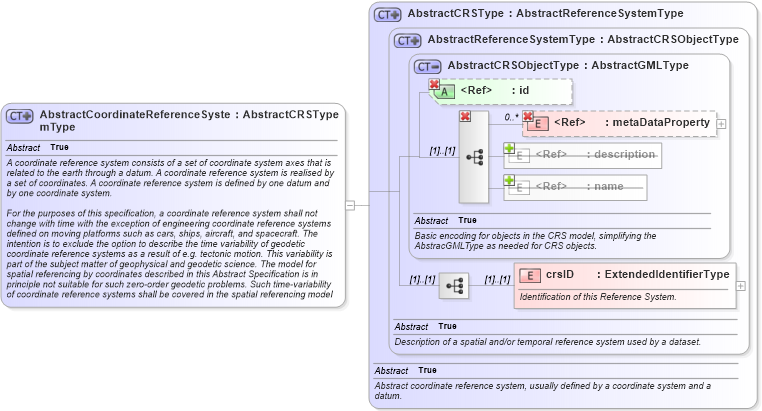
<xsd:complexType name="AbstractCoordinateReferenceSystemType" abstract="true" xmlns:xsd="http://www.w3.org/2001/XMLSchema">
    <xsd:annotation>
        <xsd:documentation>A coordinate reference system consists of a set of coordinate system axes that is related to the earth through a datum. A coordinate reference system is realised by a set of coordinates. A coordinate reference system is defined by one datum and by one coordinate system.

For the purposes of this specification, a coordinate reference system shall not change with time with the exception of engineering coordinate reference systems defined on moving platforms such as cars, ships, aircraft, and spacecraft. The intention is to exclude the option to describe the time variability of geodetic coordinate reference systems as a result of e.g. tectonic motion. This variability is part of the subject matter of geophysical and geodetic science. The model for spatial referencing by coordinates described in this Abstract Specification is in principle not suitable for such zero-order geodetic problems. Such time-variability of coordinate reference systems shall be covered in the spatial referencing model described in this document by creating different coordinate reference systems each with a different datum for (consecutive) epochs. The date of realisation of the datum shall be included in its definition. It is further recommended to include the date of realisation also in the names of the datums and the coordinate reference systems.

Coordinate reference systems are commonly divided into sub-types. The common classification criterion for sub-typing of coordinate reference systems is the way in which they deal with earth curvature. This has a direct effect on the portion of the earth's surface that can be covered by that type of CRS with an acceptable degree of error. The exception to the rule is the subtype "Temporal" which has been added by analogy. </xsd:documentation>
    </xsd:annotation>
    <xsd:complexContent>
        <xsd:extension base="gml:AbstractCRSType" />
    </xsd:complexContent>
</xsd:complexType>
Collapse Child Elements:
Name Type Min Occurs Max Occurs
metaDataProperty gml:metaDataProperty 0 unbounded
description gml:description 0 (1)
name gml:name 0 unbounded
metaDataProperty gml:metaDataProperty 0 unbounded
crsID gml:crsID (1) (1)
Collapse Child Attributes:
Name Type Default Value Use
id gml:id Optional
Collapse Derivation Tree:
Collapse References:
gml:_CoordinateReferenceSystemgml:AbstractGeneralDerivedCRSType, gml:EngineeringCRSType, gml:GeocentricCRSType, gml:GeographicCRSType, gml:ImageCRSType, gml:TemporalCRSType, gml:VerticalCRSType,